|
"Explore Neighborhoods Within Neighborhoods"
| |
Playa Del Rey Lease PropertiesPlaya del Rey (Spanish for "Beach of the King" or "King's beach") is a beachside community within the city of Los Angeles. The rolling hills are the result of ancient, wind-blown, compacted sand dunes which rise up to 125 feet above sea level. These dunes run parallel to the coast line, from Playa del Rey, all the way south to Palos Verdes. The community is bordered by the Pacific Ocean to the west, Marina del Rey and Ballona Creek to the north, Playa Vista to the northeast, Westchester to the east, and El Segundo to the south. History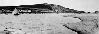
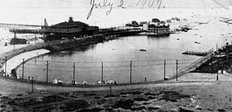
The northern part was originally wetlands, but the natural flooding was halted by the concrete channel which contains Ballona Creek. Before 1824, the harbor was the mouth of the Los Angeles River, before its course shifted to its current outlet at San Pedro. In the 1870s, Playa Del Rey was the location of the first attempt at a dredged harbor in Santa Monica Bay. Under contract with the Atchison, Topeka & Santa Fe Railroad, Moye Wicks' syndicate spent $300,000 to dredge "Ballona Harbor", for shipping to the Orient. Within three years, winter waves brought flooding, but what remained of man's early efforts became the Playa Del Rey Lagoon, now a regional public park. Palisades del Rey (also, Palisades Del Rey) was the name of original 1921 neighborhood land development by Dickinson & Gillespie Co. that later came to be called Playa del Rey. This area of sand dunes was the last stretch of coastal land in the city of Los Angeles to be developed. All of the houses in this area were custom built, many as beach homes owned by Hollywood actors and producers, including Cecil B. Demille, Charles Bickford, and others. Construction in Playa del Rey surged in 1928 with the development of the Del Rey Hills neighborhood in the Eastern part of the community (to the East of Pershing Drive), and the move of Loyola University (now Loyola Marymount University) to the adjacent community of Westchester. The southern portion of the original Playa del Rey development, which came to be known as "Surfridge," is now vacant. The houses that were once there were either moved to new locations or were demolished to facilitate the expansion of Los Angeles International Airport (LAX) and to address concerns about the noise of increasing jet plane traffic. The noise from the flights made it less desirable to live on the dunes above the ocean under the LAX flight path. The City of Los Angeles condemned the southern section of Playa del Rey under the power of eminent domain, and purchased all of the homes. Today one can see only barbed-wire fences protecting vacant land and old streets where houses once sat. Recent LAX rejuvenation plans call for the city to finally remove the old streets that still line the empty neighborhood. The condemned areas of the community are now a protected habitat of the endangered El Segundo blue butterfly. Playa del Rey in the 1950s and early 1960s was known as a great Los Angeles area "surfing spot", but due to the many rock jetties that were built to prevent beach erosion, the good surf is mostly gone. The beach at the northernmost end of Playa del Rey is still known as "Toes Over Beach", "Toes Beach" or just "Toes" by the local surfing community, a name derived from the toes over or Hang Ten surfing maneuver. Most surfers now flock south of Dockweiler Beach, to "El Porto", the most northern part of beach in the city of Manhattan Beach. Locals refer to the small area of housing south of Culver Boulevard and closest to the beach as The Jungle, a nickname given to a group of closely built apartments built in 1956, within the bounding streets Trolley Place and Trolleyway Street on its east and west respectively, and including the streets Fowling, Rees, Sunridge and Surf. The small sidewalks between homes had/have deep green overgrowth, which added to the name. Today a bridge between Playa Del Rey and the jetty between Ballona Creek and the Marina is accessible to foot traffic and bicycle traffic, but not to automobiles. Bikers, skaters and joggers probably have the best chance of traversing the sidewalks of the beaches north to Santa Monica, and to the South Bay, here at this bridge. 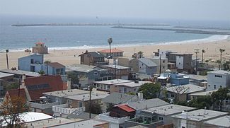
Preview all properties for lease below: Preview all properties for sale here: Preview all income properties for sale here: |