|
"Explore Neighborhoods Within Neighborhoods"
| |
Marina Del Rey Lease PropertiesMarina del Rey is a seaside unincorporated area in Los Angeles County, California. Its Fisherman's Village offers a view of Marina del Rey's dominant feature as it is the world's largest man-made small craft harbor, with 19 marinas with capacity for 5,300 boats and is home port to approximately 6500 boats. The harbor, the Los Angeles Times said in 1997, is "perhaps the county's most valuable resource". Marina del Rey is southeast of Venice and north of Playa Del Rey, near the mouth of the Ballona Creek. It is located four miles north of Los Angeles International Airport (LAX). It is bounded on all sides by the City of Los Angeles. The beach-style homes, a strip of land against the beach, and the beach itself, west of the harbor, are within the City of Los Angeles limits, but share the same zip code as Marina del Rey. The name of this strip is the Marina Peninsula. Via Dolce and the southern portion of Via Marina are the boundaries between L.A. City and the unincorporated area. 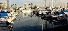
The marina itself, a specially designed harbor with moorings for pleasure craft and small boats, is surrounded by high-rise condos, hotels, apartments, shops, and restaurants. The area also includes the University of Southern California Information Sciences Institute, the UCLAMarina Aquatic Center, and the Internet Corporation for Assigned Names and Numbers, which regulates the Internet's address and domain name systems. The community is served by the three-mile long Marina Freeway (State Route 90), which links Marina del Rey directly to Interstate 405 and nearby Culver City. HistoryPrior to its development as a small craft harbor, the land occupied by Marina del Rey was a salt-marsh fed by freshwater from the Ballona Creek, frequented by duck hunters and few others. Burton W. Chase, a member of the Los Angeles County Board of Supervisors, referred to the area as the mud flats, though today the area would more properly be referred to as the wetlands. In the mid-19th century, M.C. Wicks thought of turning this Playa del Rey estuary into a commercial port. He formed the Ballona Development Company in 1888 to develop the area, but three years later the company went bankrupt. 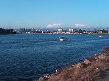
In 1916, the U.S. Army Corps of Engineers revisited the idea of a commercial harbor, but declared it economically impractical. In 1936 the U.S. Congress ordered a re-evaluation of that determination, and the Army Corps of Engineers returned with a more favorable determination; however, the Marina del Rey harbor concept lost out to San Pedro as a commercial harbor and development funding went to the Port of Los Angeles instead. In 1953, the Los Angeles County Board of Supervisors authorized a $2 million loan to fund construction of the marina. Since the loan only covered about half the cost, the U.S. Congress passed and President Dwight D. Eisenhower signed Public Law 780 making construction possible. Ground breaking began shortly after. With construction almost complete, the marina was put in danger in 1962–1963 due to a winter storm. The storm caused millions of dollars in damage to both the marina and the few small boats anchored there. A plan was put into effect to build a breakwater at the mouth of the marina, and the L.A. County Board of Supervisors appropriated $2.1 million to build it. On April 10, 1965 Marina del Rey was formally dedicated. The total cost of the marina was $36.25 million for land, construction, and initial operation. Points of interest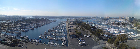
Street LayoutTraveling on SR-90, approaching the end of the Marina Expressway, this is how the street layout appears: The Marina Expressway terminates and flows into SR-1, marked additionally as Lincoln Blvd. Traveling north on SR-1/Lincoln Blvd., the first junction reached is that of Maxella Avenue, a major east-west thoroughfare. Traveling south on SR-1/Lincoln Bl., the first junction reached off the Expressway is that of Bali Way, which connects to Admiralty Way, which encircles the Northern Marina as a whole. Admiralty Way terminates at Via Marina on its western end. Most major businesses and buildings in the Marina are situated along Admiralty Way, which is, in some ways, the Marina's Main Street. As part of the man made design of the boat harbor, there were seven basins built and there are 7 respective jetouts from those basins, each of which has at least one street. From the northeastern end of the Marina, going clockwise, these streets are: Bali Way, Mindinao Way (terminates at Burton Chace Park), Bora Bora Way, Tahiti Way, Marquesas Way, Panay Way, and Palawan Way. Panay Way, Marquesas Way, Tahiti Way, and Bora Bora Way are all on the western side of the Marina and all terminate at Via Marina. Palawan Way is also on the west side, but it terminates at Washington Blvd. Neighborhoods
Preview all properties for lease below: Preview all properties for sale here: Preview all income properties for sale here: |