|
"Explore Neighborhoods Within Neighborhoods"
| |
The Neighborhood Of BrentwoodThe Los Angeles district is located at the base of the Santa Monica Mountains, bounded by the San Diego Freeway on the east, Wilshire Boulevard on the south, the Santa Monica city limits on the southwest, the border of Topanga State Park on the west and Mulholland Drive along the ridgeline of the mountains on the north. Nearby neighborhoods and cities include Pacific Palisades on the west, Santa Monica on the south, West Los Angeles and Sawtelle on the southeast, Westwood on the east, Bel-Air on the northeast and Encino on the north. Mail to the Brentwood district is addressed, Los Angeles, CA 90049 to avoid confusion with the municipality of the same name in Northern California. HistoryThe area that is now Brentwood was part of the Rancho San Vicente y Santa Monica, a Spanish land-grant ranch sold off in pieces by the Sepulveda family after the Mexican-American War. Development began following the establishment of the large 600-acre (2.4 km2) Pacific Branch of the National Home for Disabled Soldiers and Sailors in the 1880s. A small community sprang up outside that facility’s west gate, taking on the name Westgate. Annexed by the City of Los Angeles on June 14, 1916, Westgate’s 127 km2 (49 mi2) included large parts of what is now the Pacific Palisades and a small portion of today’s Bel-Air. Westgate Avenue is one of the last reminders of the area’s former namesake. The Sunset Fields Golf Club, now the Brentwood Country Club, hosted the running part of the modern pentathlon event at the 1932 Summer Olympics. Originally planted with soybeans and avocados, Brentwood is now one of the prominent districts of the Westside and among the wealthiest neighborhoods in all of Los Angeles. It has prosperous commercial districts along each of its major east-west thoroughfares, Wilshire Boulevard, San Vicente Boulevard and Sunset Boulevard. Though there is no direct connection, the name Brentwood harks to Brentwood of Essex, England, a town on the outskirts of London dating back to Saxon times. Many local streets reflect this ersatz British heritage, including Barrington, Gorham, and Bristol. Local traditions include the annual decoration of San Vicente Boulevard’s historic coral trees with holiday lights and a Maypole erected each year on the lawn of the Archer School for Girls, carrying on the tradition set by the Eastern Star Home that was previously housed there. (Classic film lovers are familiar with this building as the exterior establishing shot for the “Mar Vista Rest Home” that provides a key scene in the 1974 film Chinatown.) Inspired by the community of veterans resident at the former Soldiers and Sailors Home, now a United States Department of Veterans Affairs Medical Center, Brentwood once regularly hosted a Memorial Day parade, complete with a string of classic cars and an elephant named Tiny; the tradition is now only sporadically practiced due to funding. Brentwood received notoriety in 1994 when Nicole Brown Simpson, ex-wife of football legend O.J. Simpson, and her friend Ronald Goldman were found stabbed to death outside her Bundy Drive condominium. Simpson was arrested for the murders and later acquitted by a jury in a heavily-publicized trial. 1961 Brentwood-Bel Air fireOn November 6, 1961, a construction crew working in Sherman Oaks in the San Fernando Valley north of Brentwood on the far side of the Santa Monica Mountains noticed smoke and flames in a nearby pile of rubbish. Within minutes, Santa Ana winds gusting up to 60 mph (100 km/h) sent burning brush aloft and over the ridge into Brentwood. More than 300 police officers helped evacuate 3,500 residents during the 12-hour fire, and more than 2,500 firefighters battled the blaze, pumping water from neighborhood swimming pools to douse flames. Pockets of the fire smoldered for several days. Even as firefighters battled what was to become the Bel-Air disaster, a separate fire had erupted simultaneously in Santa Ynez Canyon to the west, further straining local firefighting resources. That blaze was contained the next day after consuming nearly 10,000 acres (40 km2) and nine structures and burning to within a mile of the inferno raging in Bel-Air and Brentwood. At least 200 firefighters were injured but no one was killed and 78 percent of the homes were saved. Still, the fires were the fifth worst conflagration in the nation’s history at the time, burning 16,090 acres (65 km2), destroying more than 484 homes and 190 other structures and causing an estimated $30 million in damage. EnvironmentBrentwood, like nearby Santa Monica, has a temperate climate influenced by marine breezes off the Pacific Ocean. Residents frequently wake to a “marine layer,” a cover of clouds brought in at night which burns off by mid-morning. The topography is generally split into two characters, broadly divided by Sunset Boulevard: the area north of Sunset is defined by ridges and canyons of the Santa Monica Mountains; south of Sunset the area is relatively flat. The southern district features underground springs which bubble up into a small creek along “the Gully” near the Brentwood Country Club, and in the “Indian Springs” portion of the University High School campus, formerly the site of a Native American Tongva village. 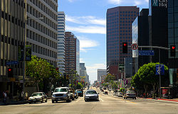 A view of Wilshire Boulevard westbound, towards the ocean. Brentwood begins on the right-hand (north) side of the street.
San Vicente Boulevard is considered the “Main Street” of Brentwood and is divided by a wide median on which stand many large and attractively sculpted coral trees. This green belt replaced a derelict Pacific Electric trolley track, its trees evolving into a City of Los Angeles Historic-Cultural Monument. Brentwood boosters have adopted a coral tree silhouette as a de facto community logo. Intersecting Bundy Drive is lined with extremely tall Washingtonia robusta palms. NeighborhoodsBrentwood features a number of residential subdistricts, some as small as a few blocks, others ranging over acres of hills:
Preview all properties for lease below: Preview all properties for sale here: Preview all income properties for sale here: |